|
The engineering half of my brain has gone into overdrive the last two days, thinking about how people who bicycle are accommodated through various designs in Copenhagen. There's an old TED talk from 2012 (see below) that I first saw 6 or 7 years ago when I was in graduate school and became interested in bicycle transportation. It's a by Mikael Colville-Anderson who talks about how we got the urban form and focus on cars we have today, but more importantly, what good infrastructure looks like. It struck a chord with me because he discusses the difference between engineering and design. Engineering is using computer models and paper maps to assume how people will use a facility, whereas design involves thinking about what is best for the end user, and then creating a system that works for them. Maybe that's a bit of semantics, but to me it makes perfect sense when you bike around Copenhagen. The system is designed for people who bike, down to the signals, intersections, parking, and train. So what exactly does this mean, a system that is "designed" for people who bicycle? In the United States we have the Manual on Uniform Traffic Control Devices (MUTCD for short, last fully updated in 2009, which prescribes every type of intersection you might encounter, what it should look like, the markings to use, the number, size and location of signals. There is little guidance, or even images, of people walking, or biking or interacting with cars and intersections. Yet in a dense city, oftentimes people significantly outnumber cars at every intersection during the busier times of day. The TED talk goes on to describe that a city "designed" for people is one that is intuitive and easy to navigate. In the United States we've made it easy for people to drive everywhere, and for the most part we've made it intuitive (yet there are still 40,000 deaths a year from traffic crashes). In Copenhagen, they've designed the city for people who bicycle. What does this mean? They've made it natural, intuitive and easy to navigate, travel and park bicycles. When a bicycle lane crosses an intersection, there are pavement markings directing you from one end of the lane to the next. Bicycle signals are at the rider's height and have a small symbol to illustrate who it's for. Parking options are abundant, yet it's also "allowed" to park anywhere that's not in the way of the sidewalk. Construction sites have dedicated lanes for bicyclists to use if they're blocking the lane, and every transition from one grade to another where a bicyclist may traverse has a small ramp to make it easier. In a way, what the United States has done for cars, Denmark/Copenhagen has done for bicyclists, and it's in this way that travel by bicycle is the most common and preferred way to travel. While the transit system here is robust (3 minute train headways on a Sunday), bicycle travel is competitive with transit for short distances. Below is a screenshot from Google maps where you can the fastest way to get somewhere was by bicycle. 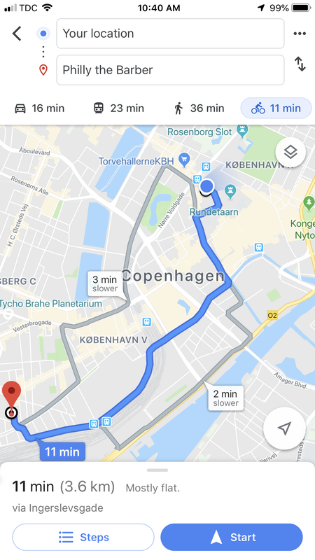
2 Comments
Anya L Dobrowolski
7/8/2019 03:09:22 pm
Nick! I'm loving your blog. The comment about Copenhagen accommodating cars the way that the US is working to accommodate bicycles now really resonates. It seems like, in the US, we committed an "original sin" of morphology with so much of our cities evolving after the car became so accessible (Eugene, for instance, really grew after the Army Corps channelized Amazon Creek in the later 30's/early 40's). So the American city and suburb were designed for cars because of the coincident technological changes that were happening, not just the availability of cars but building technologies, new materials, etc. (All made possible by cheap petroleum, I imagine.) So all this rambling is to say, if Copenhagen had been developed at the same time as Eugene, it might look a lot more auto-centric than it does. I guess this all makes me wonder if we can bring a European cycling sensibility to American cities that already have such heavy and entrenched infrastructure. Perhaps we need to just burn it all down and start over? When you get home more porch sitting and philosophizing will be in order.
Nick Meltzer
7/10/2019 12:53:05 pm
Anya! Great question. From what I'm learning, the streets here used to be as wide as the current streets in the US. They used to use their public plazas for parking lots! However there was demand for solutions to congestion, and being a poor city (back then) Copenhagen decided the best way to deal with congestion was to remove vehicle lanes and add cycle tracks! The majority of their cycle tracks have been retrofitted simply by adding a raised lane. I sometimes wonder if the density issue makes a difference, but at the same time, if you build a complete network of bicycle infrastructure across your city, shouldn't everyone be able to get where they need to go on a bike and density doens't matter as much? Leave a Reply. |
 RSS Feed
Photo used under Creative Commons from Ivan Radic
